 |
The
south-western suburb of Beirut encompasses a large community
living in sub-standard and illegal conditions. The improvement
of both social and physical fabrics of the area necessitated
the creation of a public agency responsible for the planning
and development of the entire district. This agency was named
ELYSSAR administered by seven member's board headed by a
President acting also as a General Manager .
ELYSSAR,
established as per Decree No 9043 dated 30/08/1996, enjoys an
administrative and financial autonomy, and commercial real
estate development prerogatives to fulfill its mission under
the direct supervision of the Prime Minister.
The
Preliminary Master Plan for the area promulgated in June 1995,
followed by the Final Master Plan, ratified by Decree No 10231
dated 09/05/1997, specify the following :
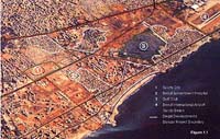
- The zone of
intervention (560 hectares of urban and water front
properties).
- The geographic
boundaries :
To the North : Adnan Hakim street to
Chatila Round About To the
West : The Mediterranean Sea
To the South : International Beirut Airport Limits
To
the East : International Beirut Airport Road . · The
general land use configuration of the area.
- The zoning plan which
delineates the boundaries of planning zones used for
development control purposes.
- The sector plans which
incorporate development controls applicable to each zone.
- The written document
of the general and specific regulations applicable to each
individual zone.
ELYSSAR
has undertaken as of November 1995 all the necessary
socio-economic survey, utilities investigations, building and
establishment survey, as well as researched all the legal and
cadastral requirements, and produced the detailed plans of the
area in order to identify the location and type of affordable
housing, new workshops and light manufacturing, parks, public
facilities and community service centers, and major attractive
and tourist centers.
|
|