LOCATION &
PREVAILING DEVELOPMENT PATTERN
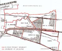
The
Elyssar project area forms an integral part of Greater Beirut.
Situated around 3.5 kms south of the Beirut Central District,
it is well placed in relation to major planned highways and
other developments in the Metropolitan area.
The
project area extends over an area of around 586 hectares (ha)
from Summerland and Sports City in the North to the boundary
of Beirut International Airport in the South. From the East it
is bounded by Airport road and from the West by the
Mediterranean Sea. Its existing population has been estimated
at around 130,000 in 1995.
Included
in the project area are the localities of Jnah, Hay Al Zahra,
Sabra-Chatila, Bir Hassan, Horch al Katil, Ouzai, Al Maramel,
and Raml Al-Aali.
The
project area is mostly occupied by residential land use. There
are however, significant areas of commercial and workshop use
along the main road in Jnah and Ouzai and a busy local
shopping area in Sabra-Chatila.
The Sports
City Stadium is prominently located in the northern part of
the Study area, while the Golf Club occupies a large area in
the central southern part.
Government
facilities face Sports city and the entertainment/tourist
complexes of Summerland and Coral Beach adjoin each other with
sea front locations. The project area, in terms of
development, has been classified into 4 broad categories:
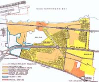
(i) Areas
typified by low rise, poor quality construction and unplanned
layouts. Most of these areas are illegally occupied. There are
6 major areas of predominantly illegal development, in Hay
Al-Zahra, Sabra-Chatila, Jnah, Horch Al-Katil, Ouzai and Al
Maramel. They total around 160ha, which represents almost 30%
of the project land area.
(ii) Areas
typified by medium rise, fair and good quality construction
built on planned subdivisions. Most of these areas are legally
occupied and not yet fully developed. There are 5 areas of
legal development in Hay Al-Zahra, Bir Hassan, Raml Al-Aali,
parts of Horch Al-Katil and northern Sabra-Chatila.
(iii)
Vacant land in Al Maramel and Raml Al-Ali. These areas total
some 43 ha and are not yet subdivided.
(iV) Areas
containing a mixture of legal and illegal development in
Ouzai/Jnah and in the Eastern part of Sabra-Chatila. |